Malibu Lagoon Restoration Phase 1
|
|
|
|
|
|
|
|
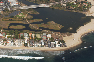
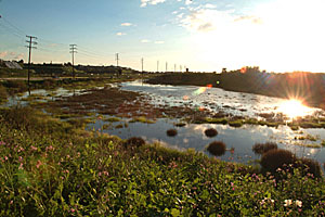
Malibu, CA
Duvivier Architects did the schematic
designs for the Malibu Lagoon Restoration – Phase 1. Malibu
Lagoon drains into the Pacific Ocean at Surfrider beach in Malibu.
While beautiful, the water quality at Surfrider is famously unhealthy
due to pollutant loads from Malibu Lagoon and the creek that runs
through Malibu Canyon from Agoura Hills and adjacent inland cities.
Phase 1 Restoration was primarily a parking lot redesign to provide
the following benefits: storm water infiltration through the use
of permeable paving and vegetated swales, shade for cars, native
habitat throughout, places to gather and sit, an area for students
to learn about the lagoon and the critters that occupy the lagoon.
|
slide show
(click picture)
|
|
|
top
San Pedro Sustainable Waterfront Plan
|
|
|
|
|
|
|
|
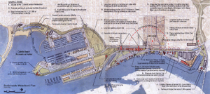
San
Pedro , CA
"Informal discussions were
brewing for the current plan when Venice-based architect Isabelle
Duvivier gave things a kick in the pants. Duvivier, who has done
two extensive studies related to the California Coastal Trail in
the Harbor Area, was an alternate in the negotiations between the
Port and the TraPac Lease appellants." according to Random
Length News. “David Freeman seemed to express genuine interest
in what the stakeholders had to say, but there wasn’t a forum
to discuss our concerns,” Duvivier recalled. So she suggested
setting up a meeting specifically devoted to waterfront concerns.
The Sustainability Plan as presented
by Duvivier includes the following:
1. All berths to be located at
the inner harbor.
2. Provide linkages to downtown and community.
3. Provide links to and protection of existing open space.
4. Expand saltwater marsh habitat.
5. Ports O' Call—Develop/enhance 150,000 square feet commercial,
a conference center, open space.
6. Create diversity of parking options to discourage traffic and
encourage pedestrian activity downtown.
7. Create a plan that reflects sustainability goals.
The last point was key, in that
it articulated the underlying unifying themes. These include:
• Plan the entire waterfront, including Westways, Warehouse
One, Fruit Terminal and Scout Camp.
• Maintain Cabrillo Bay for recreational use.
• Create a waterfront business plan to describe the economic
development goals, determine the mix of commercial, retail and educational/cultural
uses development and enhance downtown businesses.
|
slide show
(click picture)
|
|
|
top
Los Angeles Harbor Area-California
Coastal Trail Access Analysis
|
|
|
|
|
|
|
|
San Pedro/
Wilmington, CA
Duvivier Architects was selected
by the California State Coastal Conservancy to produce the
Los Angeles Harbor Area – California Coastal Trail Access
Analysis. This is an analysis of existing conditions and proposed
recommendations for a continuous California Coastal Trail
in the Los Angeles Harbor Area from the Palos Verdes Peninsula
to the Los Angeles River.
The California Coastal Trail
is a continuous public right-of-way along the California coastline.
The trail is designed to foster appreciation and stewardship
of the scenic and natural resources of the coast through hiking,
biking and other complementary modes of non-motorized transportation.
This trail is meant to:
- Provide a continuous connection to the shoreline at appropriate
intervals.
- Allow sufficient transportation access to encourage public
use.
- Enhance the user experience of contributing to the protection
of the natural environment and cultural resources while accesing
beaches, scenic vistas, wildlife viewing areas, recreational
or interpretive facilities, and other points of interest.
- Create linkages to other trail systems and urban population
centers. |
slide show
(click picture)
download
document (26.3MB) |
|
|
|
top
Los Angeles Harbor Area Public
Access & Urban Waterfront Plan
|
|
|
|
|
|
|
|
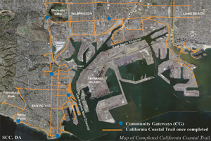
San
Pedro/ Wilmington, CA
The California State Coastal Conservancy's
Los Angeles Harbor Area Public Access & Urban Waterfront Plan
will help to complete the California Coastal Trail, by closing the
gap in the L.A. Harbor Area.
Duvivier Architects was selected
by the California State Coastal Conservancy to prepare the Los Angeles
Harbor Area Public Access & Urban Waterfront Plan.This plan
furthers the efforts of the Los Angeles Harbor Area - California
Coastal Trail Access Analysis, by developing specific recommendations
for Coastal Gateways. These community "gateways" connect
inland communities to waterfront and shoreline areas and to future
and proposed Restoration Projects in order to encourage the conservation,
restoration and enhancement of coastal natural resources and watersheds.
This plan also includes concept and design plans for several Early
Implementation Projects such as:
-
The East Wilmington Greenbelt, adjacent to the Wilmington
waterfront.
-
The San Pedro Waterfront Gateway Park, linking the
Cruise Ship Terminal via the newly completed first phase of the
Waterfront Promenade to Knoll Hill and the 110 Freeway corridor,
west to Gaffey Street.
-
Beacon Street Bluffs and San Pedro Plaza Park, extending
along the central San Pedro waterfront.
-
The Point Fermin Coast, extending from Sunken City/Pacific
Avenue to White Point/Shoreline Park, along Paseo Del Mar.
Development of this plan has been
closely coordinated with the current San Pedro and Wilmington waterfront
projects being managed by the Harbor Department of the City of Los
Angeles and with the Harbor/Watts Economic Development Corporation.
Design and site plans were prepared by Duvivier Architects, Marc
Beyeler of the SCC, CMG, Mia Lehrer + Associates and SMWM.
|
download
document (4.6MB)
The East Wilmington Greenbelt
The San Pedro Waterfront Gateway Park
Beacon Street Bluffs and San Pedro
Plaza Park
The Point Fermin Coast
slide shows
(click picture)
|
|
|
top
Ballona Wetlands Interim Stewardship
and Access Management Plan
|
|
|
|
|
|
|
|
Marina
del Rey, CA
The State of California acquired
the Ballona Wetlands in 2003 and 2004 because it is one of the most
significant wetland resources in Southern California. Following
its acquisition, the State Coastal Conservancy (SCC), in collaboration
with the California Department of Fish and Game (DFG), State Lands
Commission (SLC), other agencies and various community and conservation
organizations, began the wetland restoration planning process.
Duvivier Architects was hired by the State Coastal Conservancy (SCC)
to create the Interim Stewardship and Access Management Plan, which
is the first visible step in a series of planning efforts to protect
the Ballona Wetlands. This working plan is intended to serve as
a guide to manage short-term access and restoration and educational
opportunities for three plus years, through the completion of the
Wetland Restoration Plan.
The goals of the
plan are to:
- Create a handbook and a working
plan for short-term stewardship and access over the next 3+ years.
- Provide public access and recreational opportunities compatible
with habitat, fish and wildlife conservation.
- Encourage public appreciation of Ballona Wetlands.
- Develop a functional equivalent of a DFG Land Management Plan
for the near-term until the final plan is adopted.
- Complement and advance existing activities being undertaken within
Ballona Wetlands.
- Redirect non-complementary uses and activities from the Ballona
Wetlands.
- Develop signage as needed, in a form and scale appropriate to
the setting to enhance visitor education.
- Facilitate trash management.
The guiding principles
of Interim Stewardship and Access Management are to:
- Build on what is working now: the
ability of projects and programs to build on already successful
efforts.
- Enhance partnering and improve working relationships: build on
the existing strengths of community non-profits and encourage joint
problem solving and public-private partnerships.
- Encourage operational simplicity: undertake programs and projects
that facilitate monitoring and management without complex arrangements.
- Provide linkages to other ongoing or emerging efforts being undertaken
in the watershed: encourage communication between agencies and organizations
working in the Ballona Watershed.
- Dont compromise future restoration efforts: work smart,
focus interim stewardship efforts on projects that will be consistent
with and supportive of the long term restoration plan.
- Leverage projects for their educational and interpretive aspects:
provide teaching tools and articulate lessons learned with each
undertaking within the wetlands.
- Offer an appropriate level of managed community access: provide
a balance of resource protection, public safety and passive recreation. |
slide show
(click picture)
download
document (7.0MB)
|
|
|
top
Crystal Cove Historic District Restoration
|
|
|
|
|
|
|
|
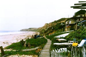
Crystal
Cove, CA
California
State Coastal Conservancy
2001
One of the few remaining undeveloped beach and riparian habitats
left in Orange county, Crystal Cove is degraded and fragile. Any
development will have a substantial impact on the Cove's future.
As pressure from interested parties heighten, it is critical that
the preservation and restoration of the Cove be paramount during
plans for any future development.
The State Parks Department is currently in the planning stages for
the development and restoration of this area. It is the goal of
the Department of Parks & Recreation "to provide for the
health, inspiration and education of the people of California by
helping to preserve the state's extraordinary biological diversity,
protecting its most valued natural and cultural resources, and creating
opportunities for high-quality outdoor recreation".
Duvivier Architects was consulted to review the Park Services plan
and prepare recommendations based on the comments of the stakeholders.
The recommendations covered on-site ecology, historic architecture
restoration and planning processes.
It was found that the creek/ocean ecology, sand replenishment and
coastal scrub restoration will not survive if overshadowed by issues
of parking, use or occupancy. Due to the special circumstances and
the fragile nature of the site, Crystal Cove must be a model for
using new technology, educational innovations and stewardship of
the built and the natural environment.
|
slide show
(click picture) |
|
|
top
Alcima
Project Restoration
|
|
|
|
|
|
|
|
Pacific Palisades,
CA
current |
slide show
(click picture) |
|
|
top
Rethinking
Suburbia: Suburban Revitalization and Design Guidelines
|
|
|
|
|
|
|
|
Benecia
- Southhampton, CA 1994
While some
suburbs are prospering, many others are facing problems such as
excess traffic, smog, decentralization and lack of open space. Professionals
from many fields have defined and implemented potential solutions
for future developments, but not many address the existing suburbs.
Duvivier Architects analyzed how an existing suburb, over time,
could be modified with the help of the community driven by some
basic, yet innovative, planning changes.
This project includes all facets of a neighborhood revitalization
plan. Southhampton, a low-density, suburban community, established
their goal to become more economically and environmentally sustainable.
As a step toward that goal, the proposal introduced a new mixed-use
commercial core, employment opportunities, and mixed-density housing.
The plan also proposed streetscape improvements, infrastructure
changes, transportation recommendations, and design and landscape
guidelines. The final report was presented to the community in 1994.
With a minimum amount of rezoning, an existing monotonous section
of Southhampton could become a mixed-use core that is easily adaptable
to the changing needs of the community.
Proposed design guidelines for Southhampton include:
- Zero lot lines.
- Altered zoning in certain areas to encourage density in the central
core.
- Common, mid-block walkway in exchange for decreased front yard
set back.
- Pedestrian and bicycle connections along superblocks.
- Facilitation of remodeling to encourage ongoing community involvement.
Impact of changes on the community include:
- Less commuter miles traveled.
- Encouragement of residents to add to and personalize their units.
- Higher community employment. |
slide show
(click picture) |
|
|
top
OTHER
PROJECTS
Park(ing) Day in
San Francisco
In San Francisco, the REBAR group and
Trust for Public Land organized a mass reclamation of automobile parking
spaces to provide temporary green space for pedestrians to enjoy.; Park(ing)
Day, a day when volunteers turned parking spaces into parks. 70% of San
Francisco’s downtown outdoor space is dedicated to private vehicle.
Over two-dozen parking spots were liberated.
Some were transformed into lush, green creations complete with sod, trees
and benches. Other organizations experimented with the idea, creating
eclectic installations like artwork, benches and gardens one such space
even features a self-serve lemonade stand!
On September 21st, I went to San Francisco
to participate in Park(ing) Day. My friend Charlie Milgrim, a Bay Area
artist and I created a sculpture park in front of SFMOMA. Our park was
called PETRO Park(ing) and the sculpture featured in our park is called
“Waste Stream”. Both are a commentary on the abundance of
petroleum based waste found in our society. Our artificial stream was
created from the packaging waste generated from a classroom worth f new
computers. By feeding the meter of our parking space we rented precious
downtown real estate. (25 cents for 10 minutes.)
A New York videographer documented
the event. Click
to see the link.
City Of Rialto Streetscape
1997
City of Rialto Redevelopment Agency
Rialto, CA
Duvivier Architects was hired to do a series of alternative site designs.
These designs were to be used as models for pedestrian friendly development
along Rialto's dysfunctional, yet improving commercial corridor. The prototypes
are used to inform and educate future developers, business owners and
city staff about how automobiles can be accommodated, while maintaining
a pleasant and efficient pedestrian environment.
L.A. Rugby Club Playing Field
and Clubhouse 1997
L.A. Rugby Club, (Carson,
California)
Carson, CA
This multi-faceted project includes designs for the playing fields, surrounding
park areas and a clubhouse for the Los Angeles Rugby Club. The Club is
seeking approval and funding for a permanent practice field at Victoria
Park. The site plan design reflects the variety of stakeholders involved.
There are 2 rugby fields, 2 cricket fields, a restored creek/nature center,
temporary shelters (for the annual Samoan festival) and a clubhouse to
be shared by all. The project is waiting for funding approval.
top
projects:
architecture
| mapping
|